Wednesday, February 28, 2007

Right Airport, Wrong Approach

I went on a short training flight today with an instrument student in his C182, equipped with both a Garmin 430 and an MX20. My plan was to do a short flight to two nearby airports, New Richmond (KRNH) and Osceola (KOEO) and then return to Anoka (KANE), doing an approach at each airport. So he created a flight plan for our route. Entered into FPL0, it showed New Richmond as our active waypoint, which was precisely what we wanted.


When he selected PROC to load the GPS approach into KRNH however, it did not display the approaches for New Richmond, in spite of New Richmond being the active waypoint. The approaches for Anoka (KANE) were displayed, and this was not what was wanted.


So how to do you get the approaches for New Richmond, which is where we’re headed? As you might suspect, there is a trick to doing it. While in the PROC page shown in Figure 2 and with the cursor activated, press MENU, and then press MENU a second time. The first time you press MENU, the named approaches box will disappear and you will be left with the box showing the highlighted approach in green, as shown in Figure 3.


When you press MENU a second time, it will bring up a dialog box that allows you to change which airport you want, as shown below.


When you turn on the cursor and select “Select Next FPL Apt?”, magically the approaches for KRNH appear. Now you can select the approach you want at New Richmond, and life is good again.


Just make sure, however, that the approach you planned on doing is really available. More on that next time, subtitle “How Little Things Can Really Trip You Up.”

Thursday, February 15, 2007

PLUGG or PLUGS?

I was working with another CFI this week who wanted more practice on using the Garmin 430. The sim provides an ideal venue for doing this, and I had been taking full advantage of it, putting him into all sorts of scenarios involving the 430. One completely unplanned teaching experience occurred however, and it is well worth sharing with readers.

He had been working through a series of exercises using the FPL0 page. He was on a route from KANE (north of Minneapolis) to KSTC, about 50 miles northwest of KANE. There is an intersection between the two airports, named PLUGS intersection. I asked the student to modify his route in FPL0, so that he would first go to PLUGS and then to KSTC. So he went to the FPL0 page, turned on the cursor, scrolled down to where he wanted to insert the PLUGS waypoint and started the necessary knob twirling to insert the waypoint. By the time he got to the “U” position, the 430 had enough information to try an auto-complete of the waypoint. So it completed the waypoint as shown below.


He then proceeded to hit ENT and PLUGG was inserted into FPL0. In this case, however, the 430 had led him astray. The intersection he wanted to insert was PLUGS. However there is a PLUGG intersection, but it happens to be in the southeast part of the country. A quick “sanity check” would have prevented the error. The lesson here is to always check the waypoint you are inserting is really the one you want. The GPS will try to help you out by auto-completing waypoints, but you must always check what it is helpfully offering to you.

Thursday, February 08, 2007

A Eureka Moment

Every once in a while in this instructing business, you have what can only be described as a “eureka” moment. An insight occurs to you that is so simple and so obvious, you just have to sit back and ask yourself “Why didn’t I think of this 15 years ago?”

Such a moment occurred a week or two ago, when I was working another instructor in the sim. He is prepping for a possible interview and had specifically asked me to concentrate on holding. So I was giving him multiple holding clearances that would mandate all possible types of entries. I have written before about how to create holding clearances – at Holding Clearances

That all worked fine and well, but I needed to give the student some way of intuitively knowing which way to turn on a teardrop entry without resorting to drawing the hold. In thinking about it, I realized that when you approach a hold for a teardrop entry, you are essentially looking at the mirror image of the hold, so to speak If it is a teardrop entry for a right-hand hold, you need to turn to your left. If it is for a left-hand hold, then you need to turn to your right. So why not teach your student to use their hand to determine which way to turn? For example, you are approaching a right-hand hold, as shown in the following graphic.


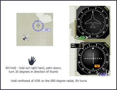
You are southwest of the VOR, and your holding clearance is to hold northeast of the VOR on the 080° radial right-hand turns. You know that your outbound heading is going to be 080 degrees, but sometimes it is difficult to see which way to turn 30° off of the outbound course without drawing it out. But suddenly I realized you can use your hand to easily figure it out. Right-hand hold – so hold out your right hand, palm down. You need to turn 30°off of the outbound course in the direction of your thumb. Here your outbound course is 080°. So turn 30° in the direction of your thumb away from the outbound course, or 050°

If it’s a left-hand hold, the same thing works, only you hold out your left hand. You are northwest of the VOR and your holding clearance is:

Hold southeast of the VOR on the 140° radial left-hand turns

So hold out your left hand, palm down, and turn 30° off of your outbound course, in the direction of your thumb. So you would turn to 170° for your initial teardrop entry.

I’ve seen a lot of different tips and aids for helping instrument pilots determine which way to turn, but I think this is about the easiest one by far. As I said, every once in a while these “eureka” moments occur.