Tuesday, October 30, 2007

Substituting GPS for DME and ADF

I work with a lot of plane owners, and I have found the trend is to install an IFR GPS and skip having a DME in the plane. After all, the IFR GPS can be used in place of DME – right? Yes it can, but you had better have a clear understanding of how that substitution is to be done if you want to stay squeaky clean with the FAA.

The 2007 AIM, section 1-1-19 has information that every pilot flying with an IFR GPS should take the time to read. Specifically 1-1-19(f) talks about the substitution of an IFR GPS for DME or ADF. Before jumping into this discussion, it must be noted that your GPS must have a current database card.

Let’s look at the DME requirements first. Let me offer a caveat up front. I confess to having a difficult time following the AIM numbering scheme. Having said that, I will jump into this discussion, hoping I have the numbers right.

The first point to note is in AIM 1-1-19(f)(5). It says that in order to use the GPS for DME, the course deviation indicator (CDI) must be set to terminal sensitivity. This is normally 1 nm full-scale deflection. In most situations, the GPS receiver will already be in terminal mode. However, if it isn’t, then you will need to manually select terminal mode. To do this with the Garmin 400-500 series, go to the Aux 3 page and select CDI/Alarms.


This will allow you to manually select the CDI sensitivity. Select the 1.00 nm scale.


The caveat here is that you must not forget to restore it to AUTO once you no longer need it forcibly set to 1.0 nm sensitivity.

To manually select the CDI scale for the KLN89B, go to the NAV1 page. Turn the cursor on. Position it on the CDI Deviation Indicator and press CLR until it says CDI scale. Use the small knob to select the 1.0 nm sensitivity (ARM mode). Press CLR to return the display to the CDI Deviation Indicator and turn the cursor off. When the KLN89B is in Approach mode, it is not possible to select a less sensitive scale that the current one. The default sensitivity is 5.0 nm. Unlike the Garmin units, there is no AUTO mode.


The KLN94 CDI sensitivity is selected in the same manner. For both the Garmin and the KLN units, if the sensitivity has been manually set to 1.0 nm, the unit will go to a more sensitivity setting (approach mode), but it will not go to the enroute sensitivity (5 nm) until it has been reset to AUTO (Garmin) or 5.0 nm (KLN).

AIM 1-1-19(f)(c)(2)(b) talks about using GPS to fly a DME arc, and this is the one that is probably most frequently violated, albeit unintentional. It says, in part, with the boldface type from the AIM itself:

“You must select from the airborne database the facility providing the DME arc as the active GPS waypoint.
Note: The only acceptable facility is the DME facility on which the arc is based. If this facility is not in your airborne database, you are not authorized to perform this operation.”

What that means is you can’t just merrily load the approach and fly the arc using the Map page display and the suggested headings provided by the GPS, sequencing along from waypoint to waypoint. You have to keep the DME facility as your active waypoint. It is generally possible to do this and keep the waypoints, including the arc, visible in your Map display.

Let’s look at the VOR/DME-27 into Anoka (KANE) as an example of how to do this.


This approach incorporates a couple of different examples of using GPS for DME. To get started, let’s examine the use of the GPS to fly the DME arc. The first step in doing this is to load the approach into the GPS. By loading the full approach into the GPS, we get most of the waypoints as well as the arc displayed on the Map page. Also note that the GPS is in terminal mode sensitivity.


The problem however is that GEP, the facility that provides the DME information, is not the active waypoint. It is however the MAP waypoint for the hold. We can make it the active waypoint by going into FPL0, highlighting GEP and doing a DIRECT-TO.


By doing this, we still have the waypoints displayed on the Map page, but we have now satisfied the requirement to have the DME facility as the active waypoint. The arc can be flown using the Map for positional awareness and the waypoint distance to keep us within the proper arc distance.


Turning inbound on the final approach course, we are in VLOC mode and GEP is still the active waypoint. Now that we are no longer on the arc, we can go back to using the GPS waypoints. AIM 1-1-19 f(c)(1)(b) states:

“If the fix is identified by a five-letter name which is in the airborne database, you may select either the named fix or the DME facility as the active waypoint.”

This means that the fixes in the approach (TOURI, VOR10 and RW27) may be used in lieu of GEP and the DME distance.


By going to PROC and selecting Activate Vectors-To-Final, we can replace GEP with TOURI, the FAF, and start waypoint sequencing again. But be forewarned; because this is not a GPS approach, you must leave the CDI in VLOC mode so that guidance is being provided by GEP.


Now let’s look at another approach that might trip the unwary user depending on GPS to substitute for DME. Consider the ILS-27 into Anoka.


The trap here lies in the localizer-only approach. If you load this approach from the GPS database, the step-down fix KOGGE will not be one of the waypoints in the approach. This means that you must rely on DME to identify this fix, but the facility providing the DME is the localizer, I-ANE, rather than a VOR. You can get the proper DME distance by doing DIRECT-TO IANE in your GPS. Both the Garmin and the KLN units think IANE is an intersection, but it does give you the proper DME distance for a localizer-only approach. I did talk to Jeppesen about this approach. They do not include waypoints for step-down fixes for localizer-only approaches. However Jeppesen indicated there is some thought as to possibly including them in the future.

When substituting GPS for an ADF, it is not so detailed on instructions. The AIM says the NDB must be selected from the database and the receiver must be in terminal sensitivity. This might lead you to believe you can fly a pure NDB approach using the NDB as the active waypoint in the GPS and placing the unit in OBS (non-sequencing mode). Take the case of the NDB-28 approach for Osceola (KOEO).


By now you are probably asking yourself why would anyone choose to do this when there is a GPS-28 for Osceola? Well, for quite a while there was indeed an approach plate for GPS-28/OEO but there was no corresponding GPS approach in the database. Why? Because of a runway extension, the GPS-28 approach was NOTAM’ed as NOT AUTHORIZED. In this case, you had only one choice – the NDB-28. So trying to conform to the guidelines in the AIM, the NDB-28 approach is loaded. But now you run into yet another problem. AIM 1-1-19 (f)(b)6) says:

“Charted requirements for ADF and/or DME can be met using the GPS, except for use as the principle instrument approach navigation source.”

Now the conundrum – that ancient ADF receiver in your plane hasn’t worked in years. And even if it did work, you know that loading OEO into the GPS as the active waypoint, putting the receiver in OBS mode, and forcing it to terminal sensitivity is going to do a far better job of getting you into Osceola than that old ADF receiver. But unfortunately the AIM seems to say the FAA doesn’t see it that way.

This basically means that you can hold over a compass locator or NDB using GPS, and you can use it to identify a compass locator on an ILS or LOC approach. Returning to the ILS-27 into Anoka, the primary holding fix is GEP. But there is an alternate holding waypoint at the PNM NDB, which is about 30 nm northwest of Anoka.


You can use GPS to substitute for ADF in doing this hold. Again, the receiver must be set to terminal sensitivity. At the MAP waypoint for the ILS-27 into Anoka, the GPS receiver stops sequencing and waits for instructions from the pilot. If you press OBS on the Garmin units, it automatically brings up the waypoint for the published hold, which in this case is GEP. However you don’t want to go to GEP. So instead press DIRECT-TO. The GPS will display the waypoint for the published hold in the DIRECT-TO dialogue box, with the cursor on. All you have to do is put in PNM for the desired waypoint. The DIRECT-TO works on the KLN units as well.


So now you can head off to Princeton (KPNM) and enter the alternate hold. You can either do it by placing the GPS in OBS mode and flying the hold with raw data, so to speak, or you can load the NDB-15 approach at Princeton (KPNM) and go to PNM for the missed approach, since it is the same hold. Personally I would opt for the latter, since it depicts the hold.


To summarize substitution of an IFR GPS for DME and/or ADF:


  • Current database card
  • For use on a DME arc, the active waypoint must be the facility providing the DME
  • For DME waypoints (other than an arc), if the DME waypoint has an associated name in the database, you may use the database waypoint. If not, the waypoint must be identified using the DME facility as the active waypoint
  • The GPS may substitute for an NDB or compass locator except if it is the primary navigation source for an instrument approach
  • For use in lieu of both DME and ADF, the GPS must be in at least in terminal sensitivity (1 nm)

So now you have the nuts and bolts of substituting your IFR GPS for DME and/or ADF. Find a friend and go practice this ahead of time. Or better yet, find a good sim with a GPS and go practice these skills. Flying in the soup with a controller issuing rapid-fire instructions is not the time to be figuring out which buttons you need to push to substitute your GPS for DME or ADF.

Wednesday, July 25, 2007

The Art of Going Missed - Updated

The missed approach may be thought of as a Plan B maneuver. It is normal to anticipate and expect that an instrument approach will result in a beautiful runway emerging from the mist and clag. That’s what we expect to see and our mindset tends to be “It is going to be there.” But sometimes it isn’t – and that’s when we need a Plan B.

DH or MAP point is not the time to be looking down at your approach plate, trying to find the missed approach instructions, during which time the plane will most likely continue to descend. The first part of the missed approach procedure should be firmly fixed in your mind, right alongside DH or the MAP point. You are low to the ground at that point, and you need to start reversing that situation immediately. So pitch up and power up right away. Get started climbing away from what is all-too-firm terra firma. Once you have a positive rate of climb established, then you can attend to other duties – cleaning the plane up and reporting your missed approach.

Many missed approach procedures involve climbing straight ahead to a certain altitude, then executing a turn to go to the waypoint for the hold. With more and more planes being equipped with IFR approved GPS units, it is increasingly common to have the instrument approach loaded in FPL 0, even if it is not a GPS approach. The GPS will automatically sequence through the waypoints in the approach until the missed approach point is reached. At that point automatic sequencing is suspended, and the GPS will wait for input from the pilot.

What happens next is specific to the model of GPS. The Garmin 400/500 series wait for the pilot to press the OBS button, which will bring up the published missed approach waypoint and provide guidance to it. The KLN89B and KLN94 units expect the pilot to press the DIRECT-TO button, which will bring up the waypoint for the published hold. By the way, this works on the Garmin unit too, and has some advantages. More on this later. The trick here is to know when to press either the OBS button or the DIRECT-TO button. The ILS-30 into Air Lake (KLVN) offers a good example.


The missed approach instructions are to climb straight ahead to 1500 feet, then climbing left turn to 2800 feet, to hold at the Farmington (FGT) VOR. The GPS will stop sequencing at the runway threshold. If OBS (or DIRECT-TO) is pressed at this point, the GPS gives guidance from that point to the VOR. But this is not what you want. The secret here is to delay pressing the OBS button until you have completed the climb to 1500 feet. When you press the OBS button after completing the straight-ahead climb, the Garmin 430 will display the magenta track that will take you to the holding fix, as shown below. Notice that the magenta track is offset by the distance required for you to make a standard rate turn to the desired heading.


Sometimes there may be an intermediate waypoint between the missed approach waypoint and the fix for the published hold. My best guess is that this is done to prevent the possibility of a plane hitting an obstacle while executing the missed approach. The GPS-13 at Rochester (KRST) provides an example of this.


The waypoints in FPL 0 for this approach in the Garmin 430W, look like this:


The Garmin 430 will stop automatic sequencing when RW13 is reached. If you press OBS at this point, it brings up the next waypoint in FPL 0, which is POKYI. Since there is no turn involved here, it is okay to press OBS as soon as you start the missed approach. This approach, by the way, is an LPV (precision GPS approach). I have had a Garmin 430W installed in my plane. I received the Garmin 430W/530W trainer CD from Garmin, and it does contain this approach. I will be writing future entries on the Garmin 430W unit.

I mentioned earlier that when the GPS stops sequencing through the waypoints, pressing the DIRECT-TO button is another way of bringing up the waypoint for the hold. Sometimes there is a distinct advantage to doing it this way.


  • Press OBS at the MAP point and the Garmin 400/500 series will immediately make the next waypoint in FPL 0 the active waypoint
  • Press DIRECT-TO at the MAP point and both the KLN and Garmin units will present the next waypoint in FPL 0 in a dialog box with the cursor turned on, so that it can be changed to another waypoint if so desired


So when would you ever want to utilize another waypoint for the hold. The ILS-27 into Anoka (KANE) provides a good example. This is the Jeppesen plate for the ILS-27.


Gopher VOR (GEP) is the waypoint for the published hold. However note in the upper left-hand corner of the plan view there is an alternate holding waypoint at the Princeton NDB (PNM). If you had been told to proceed to the alternate holding point, utilizing the DIRECT-TO method of bringing the waypoint for the hold would definitely be the preferred method.

Interestingly enough, the NOS version of the ILS-27/ANE shows the PNM holding point but gives the pilot no clue as to why it is on the approach plate.


To wrap this up, when you are briefing an approach, there are four items that you need to commit to memory.


  • The FAF
  • DH or MDA
  • How to identify the MAP point
  • The first part of the missed approach instructions


My experience in being a CFII for many years is that it is the last one that most people forget to do.

Sunday, June 24, 2007

The Case of the Disappearing Waypoint

T. is one of many customers who does a monthly sim session with me. He flies a Mooney, equipped with a Garmin 430W and is proficient on its use. His June sim session brought up an interesting scenario which is well worth sharing with you.

In the sim session, T. was flying an IFR flight from Anoka (KANE) to Rochester, Minnesota (KRST). For this particular flight, I had selected strong winds from the southeast. Playing the part of ATC, I directed T. to fly directly to CORDY intersection to start the GPS-13/RST.


T. loaded the approach into the Garmin 430 in the sim and activated it, with CORDY as the IAF. Unfortunately none of the Garmin 400/500 series downloadable simulators have a database current enough to contain the GPS-13/RST approach, so I will have to instead describe as best I can what happened. After T. loaded and activated the approach, FPL0 looked like this.

Approach GPS 13
CORDY (IA)
HEBAS
HUPAP (FA)
RWY 13 (MA)
POKYI
RST (MH)

I had thoughtfully set the ceiling so he would be forced to fly the missed approach, holding at the Rochester VOR (RST). As usual, T. flew it perfectly, executing the missed approach and entering the hold at the Rochester VOR, using the SUSP feature of the Garmin 430 to bring up the holding waypoint, RST in this case.

What happened next caught both of us by surprise. I told him to anticipate the ILS-13 approach into Rochester and was planning on having him do the transition from the VOR to ELLIE.


While still in the hold at the Rochester VOR, T. decided to load the ILS-13/RST approach. So he loaded it, using ELLIE as the IAF, but did not activate it since he was still holding around RST. As soon as he did this, RST disappeared as the active waypoint. This left him in a hold without an active holding waypoint.

In discussing it later, he explained his logic was to simply load the ILS approach, the logic being that he would not activate it since he was still in the hold at RST. However, as soon as he loaded the ILS approach in the Garmin, all of the waypoints from the previous approach promptly disappeared. Since RST was not a waypoint in the loaded approach, T. was left without his holding waypoint. Had he chosen RST as the starting point when he loaded the approach, he would have still had RST in the set of FPL waypoints.

It was an unexpected scenario to both of us. The bottom line is that you should not replace an approach in the Garmin 430 if you are depending on a waypoint in the current approach for navigation. Unless you are very careful, doing so can cause you to suddenly be navigating to an unintended waypoint. I think this would be a case of being up the well known creek without a proper waypoint!

Sunday, June 10, 2007

Back to Basics - Holding 101

Probably one of the weakest areas I see in working with both instrument students and instrument-rated pilots is holding. Granted, you don’t do it too often in the real world of IFR flying, but holds do come along on occasion.

In a previous article, Creating Holding Clearances, I talked about entries into holding patterns. But in this article, let’s step back even further and talk about how to draw a hold, given a holding clearance. Surprisingly, it’s an area that experience has shown me is lacking in basic understanding.

There are two broad categories of holds – published and unpublished. Published holds are drawn out for you on either an instrument approach plate or an enroute low chart. Unpublished holds are not depicted. They start with a holding clearance, and from there you are expected to translate that into the holding pattern. A holding clearance has a very definite form.

Hold [direction] of [waypoint] on the [radial or bearing] [direction of turns] [EFC]

So a hold around Gopher (GEP) VOR could be given as:

Hold northeast of Gopher on the 060° radial right-hand turns EFC

EFC is shorthand for “expect further clearance” and is a time limit, given in the event of loss of communications.

Once the holding clearance has been given, there is often a fair amount of confusion about the correct way to translate that into a graphic holding pattern. This is what I often see. The pilot will draw a line outbound from the VOR, hesitate, then draw the right hand turn at the “end” of the outbound leg. Then they will complete the pattern, which results in a left-hand holding pattern. This is how the incorrect holding pattern looks.


This all too common mistake results from confusion about where the “right hand” turn is defined. Here are the steps to drawing it correctly. Start at the VOR and draw a line outbound on the radial. Next reverse course and draw over the same line back in towards the VOR. Once you are back to the VOR, now draw the right-hand turn, and complete the holding pattern. It should look like this.


If you will follow this procedure, your holding pattern will be correct. The key point to remember is that the direction of turn, right or left, is drawn at the VOR, not out on the radial. Another key to help you get it right is to remember that when you track inbound, you want to be tracking inbound on the specified radial, with a heading that is the reciprocal of the given radial. Your outbound track is in the same direction as the given radial, but you are offset from the radial.

Monday, May 28, 2007

Using an RMI

Those of us who did instrument training before GPS took over, had to learn how to do NDB navigation. An ADF is a very simple instrument. It simply points at the NDB. Follow the needle, and sooner or later you will get to the NDB – or possibly a thunderstorm. But such a seemingly simple instrument has been the source of a great deal of frustration to generations of pilots who had to learn how to use it for navigation. If our instrument instructors were successful in beating it into our heads, we eventually learned how to intercept specific bearings and track towards or away from the NDB in a more or less precise manner. The degree of precision often depended on the degree of wind.

VORs have radials, and NDBs technically have bearings. But to simplify this discussion, I am going to use radials in talking about NDBs. If we wanted to track inbound on the 180° radial towards the station, we learned to turn to an intercept heading, usually 30, 45, or 60° for ease of use. When the head of the ADF needle fell to the intercept angle, we were on the desired radial. If our airplane was really fancy, it had an ADF card that could be rotated. This simplified things for the pilot – more or less. If you remembered and had the time to do so, you could rotate the ADF card to match the aircraft’s heading. By doing this, you didn’t have to calculate intercept angles. When the head of the ADF needle fell to the desired radial, you had made the interception. Suppose you were southwest of the NDB and wanted to intercept the 180° radial and track inbound on it. You could turn to an intercept heading of 045° and also rotate the ADF card to match your heading. The head of the ADF needle would fall, and when it reached the desired reading of 360° (reciprocal of 180°), voila – you were on the desired course.


The ADF with a rotating card was often called the poor man’s RMI. It simplified NDB navigation, but having to constantly rotate the card really added to the pilot’s workload. But what if the card rotated automatically, just like your DG (heading indicator) or HSI. That essentially is what an RMI is. It is a DG with either one or two needles that can be set to respond to either NDBs or VORs. So using an RMI is basically just remembering how you did NDB navigation.

The RMI combines the DG and ADF into one instrument. As you turn, the card moves just as the DG or heading indicator would move.


Recently I was asked about using an RMI for hold entries. So let’s investigate how you use an RMI to get into a hold. To do this, set the RMI to respond to a VOR rather than an ADF. Assume you are tracking north on the 180° radial towards the VOR.


I have marked off the face of the RMI with the lines to determine holding entry for a right-hand hold. If you don’t recall this, please refer to Creating Holding Clearances. Our holding clearance at Podunk VOR was given as:

Hold northeast of PODUNK VOR on the 050° radial, right-hand turns, EFC……

This calls for a teardrop entry. To make this entry, we would turn to a heading of about 020° after passing over the VOR and fly for one minute (if it was timed legs).


Turning right to intercept the inbound course on the 050° radial, the RMI tells us right away that we need to stop the turn momentarily to intercept the radial.


Remember the RMI acts just like an ADF. The head of the needle is going to fall. Right now the plane is on the 40° radial, but we need to intercept the 050° radial. Since the head of the needle will fall, we can stop the turn temporarily on a heading of 200° and wait for the needle to fall. When it gets to 230°, we are on the 050° radial.


Modern RMIs include those that can track two different stations simultaneously and can be independently set to either VOR or ADF. This one is from a King Air panel.


It takes a little bit of readjustment to your thinking, but once you get the hang of it, it’s really a great instrument.

Sunday, May 20, 2007

Mnemonics and Acroynms

Mnemonics and acronyms – those little cryptic collections of letters and words that help us remember things. As pilots we certainly collect more than our share of them, and we all have our favorites that we tend to use, and teach. Some of my favorites include the following. They are not listed in any order or preference – just as I happen to think of them.

GUMP, BGUMP, BCGUMP, or BCCGUMP -- all variations of the same thing. Generally used as a pre-landing checklist, the letters stand for the following:

  • B – electric boost pump.
  • C – carb heat
  • C – cowl flaps
  • G – gas on the fullest (or correct) tank
  • U – undercarriage (gear)
  • M – mixture
  • P – prop


Red-Blue-Green -- this is the checklist I use on short final.

  • Red – mixtures should be forward
  • Blue – props should be forward
  • Green – gear had better be down


IMSAFE -- used for a pilot checklist. Are you safe to fly this particular day?

  • I – illness. You don’t need to be flying if you are sick. Go home and find your couch!
  • M – medication. Are you taking any medications, prescription or OTC, that would make you unsafe? Cold medications often make you sleepy, and a sleepy pilot is definitely not a safe pilot.
  • S – stress. Are you under stress or an emotionally draining situation? If so, you don’t belong in an airplane.
  • A – alcohol. No explanation needed. Alcohol and planes (and cars) don’t mix well.
  • F – fatigue. Are you tired and worn out? If so, you definitely do not belong in a plane.
  • E – eating. Have you eaten anything lately? A candy bar and a cup of coffee do not constitute a decent meal.

I once had a student pilot cancel her solo long cross-country. She got all the way out to the run up area and then taxied back in. When she called me to tell me she had cancelled, she cited the IMSAFE checklist. She was going through a messy divorce and decided she was definitely not safe. Needless to say, I commended her highly on her decision.

ABCD -- used for emergency procedures in case of engine failure in a single-engine plane at altitude.

  • A – airspeed. Trim for best glide. In a lot of trainer aircraft, this may be close to full nose-up trim.
  • B – best place to land. Pick out a landing spot and head for it. If you get there and you are high, you can spiral down.
  • C – checklist. If time permits, turn to the emergency section of the checklist to try to restart the engine. Otherwise use a flow method of checking critical items. Primer, boost pump, switch fuel tanks, carb heat or alternate air, mags (try one or the other).
  • D – dialogue. If you are talking to a controller, let them know you have a problem. Otherwise go to 121.5 and tell anyone within reception range that you have a problem. And if time permits, squawk 7700 on your transponder. But above all, fly the airplane.


Pitch-Full-Clean-Blue-Identify-Verify-Feather -- pre-takeoff checklist for multi-engine pilots. Treat every takeoff in a twin as “this is the day I am going to lose an engine on takeoff or climb out”. Review your emergency procedures before every takeoff. This particular set is for actions to be taken in the event of an engine failure on climb out after the gear has been retracted.

  • Pitch – pitch for the horizon, because your airspeed is going to bleed off at an alarming rate. Pitching for the horizon will preserve that vital airspeed and put you roughly in the vicinity of blue line (Vyse).
  • Full – make sure everything is full forward, mixtures, props, throttles.
  • Clean – verify you are clean, both gear and flaps retracted
  • Blue – put your airspeed right on blue line (Vyse), the airspeed for best single-engine climb performance. But just remember, there is nothing that says a light twin has to climb on a single-engine. However Vyse will at least minimize your rate of descent.
  • Identify – identify which engine has failed. Most multi-engine pilots are taught the “dead foot dead engine” technique. If you set your heading bug to runway heading and then use rudder to maintain the extended centerline, your “dead” foot will indicate the dead engine. Another clue is to use the turn coordinator – step on the high wing. The plane wants to yaw towards the dead engine, so stepping on the high wing identifies which engine has failed.
  • Verify – verify that you have correctly identified the dead engine by retarding the throttle for that engine. You don’t want to shut down your only remaining good engine!
  • Feather – close to the ground and fighting for altitude, that windmilling prop needs to be feathered. A windmilling prop creates an enormous loss of mechanical energy due to it forcing the crankshaft to rotate, which it turn causes pistons to move, etc. So get rid of that energy drain by feathering the prop.

Then climb to gain some altitude and come back for a landing. This in itself presents a dilemma. Climbing straight ahead is best for gaining altitude, but at the same time it is taking you farther and farther away from the runway. What is the best choice? Your decision. You can safely turn, even into the dead engine, but make it a very gentle bank and watch that airspeed.

PARE -- spin recovery. Although you may have not gone through spin training, you can’t get a Private Pilot license without at least having learned the situations that can lead to an unintended spin and how to recover from it, should it happen.

  • P – power to idle
  • A – ailerons neutral
  • R – rudder opposite
  • E – elevator forward

In most training aircraft it also works to just take hands and feet off the controls, and the plane will generally recover by itself. But you should remember the steps in case it doesn’t. If the situation presents itself, I strongly encourage you to take spin training. No amount of talking about entry and recovery can prepare you for the shock that occurs on your first up close and personal encounter with a spin.

ANDS -- this is another one all primary students learn about the behavior of the mag compass.

  • AN – acceleration will show a turn towards the north
  • DS – deceleration will show a turn towards the south


The 5 T’s – Turn, Time, Twist, Throttle, Talk -- Taught to generations of instrument students, it details the actions to take at various points in an approach or entry into holding. Not all of the T’s will be needed at every point, but running through the list will save you from an embarrassing omission.

  • Turn – turn to the desired heading. You may need to turn to an intercept heading to get on the desired radial or bearing.
  • Time – start your timer, if needed.
  • Twist – twist the OBS to the proper setting, either required radial or the reciprocal to eliminate reverse sensing.
  • Throttle – reduce your airspeed
  • Talk – if asked to report, do so.


TITS -- the mammary gland check, used to set a navigation radio and not forget something critical while doing so.

  • T – tune in the correct frequency
  • I – identify the VOR or NDB. That Morse code is there for a reason, so use it to make sure you have tuned in a properly working VOR or NDB.
  • T – twist the OBS to the correct setting
  • S – select the correct source, GPS or land-based VOR. Since the advent of GPS, the most common installation relies on a single VOR head to display either GPS information or VOR information. Make sure you know what is driving the VOR display.


One of the most common mistakes I see, as an instrument instructor, is failure to select the proper source. Some GPS units will switch from GPS to VLOC if the active frequency is a localizer, but don’t depend on the box to do it for you. You are PIC in the airplane, not the GPS, so make sure the signals driving the VOR display are coming from the desired source.

Stuff Out -- Vs and Vso, how to remember which is which.

  • Vso – “stuff out”, meaning gear and flaps, so Vso is stall speed in the landing configuration.


TOMATOFLAMS -- aid to remembering day VFR required instrumentation and equipment.

  • T – tachometer
  • O – oil pressure
  • M – mag compass
  • A – airspeed indicator
  • T – temperature gauge for each liquid cooled engine
  • O – oil temperature for each air cooled engine
  • F – fuel gauge for each fuel tank
  • L – landing gear position indicator
  • A – altimeter
  • M – manifold pressure gauge
  • S – seat belts


FLAPS -- aid to remembering night VFR required instrumentation and equipment, in addition to TOMATOFLAMS.

  • Fuses – spare set of fuses. Planes now mostly have circuit breakers.
  • L – landing light if operated for hire
  • A – anti-collision light
  • P – position lights
  • S – source of electrical power


“There is no more red port wine left” -- how to remember the position lights.

  • For those of you who are not sailors (which includes me), it’s one way of remembering that the red position light is on the left wing.


WRITMIM -- aid to set-up for an instrument approach

  • W – weather, ATIS or AWOS
  • R – radios set-up, both com and nav, active and stand-by
  • I – instruments, check both altimeter setting and DG
  • T – figure out time from FAF to MAP
  • M – missed approach point, make sure you know how it is to be identified
  • I – inbound heading, from FAF to MAP
  • M – minimum altitude, DH or MDA


“BLT with mayo, fries and a coke” -- created and used by one of my primary students, it was his method of doing a pre-takeoff check or a pre-landing check. He would also use it as a post-landing check. He was learning to fly in a Cherokee.

  • B – boost pump on or off
  • L – landing light on or off
  • T – transponder on ALT or stand-by
  • Mayo – mixture, either rich or leaned
  • Fries – flaps, either extended or retracted
  • Coke – carb heat, either on or off


These are some of the countless acronyms that are used by pilots. Do you have some favorites that aren’t listed here? Feel free to share them. It would both a lot of fun and informative to keep expanding this list.

Sunday, May 13, 2007

Procedure Turns

What really is the purpose of a procedure turn? It’s pretty simple – you’re going the wrong way and need to get turned around. We all learned about them – those little arrows on an approach plate, showing the direction to fly away from the course, generally for one minute followed by a 180° turn back to intercept the course going in the right direction. The one shown below is the Jeppesen method of charting a procedure turn


Instrument students were taught to fly it exactly that way. To deviate was to invite the dreaded pink slip from a disapproving examiner. However things are now starting to swing to a less strict interpretation.

But there are a couple of different types of procedure turns that must be flown exactly as depicted. One of these is the teardrop reversal, as shown below.


This procedure turn is from the ILS-18 at Lincoln, NE. To do this procedure turn, the pilot must fly out on the 324° radial of the Lincoln VOR and then turn right and intercept the inbound localizer course of 174°. Funny thing, it looks exactly like a teardrop entry into a holding pattern. The 324° radial is exactly 30° offset from the outbound localizer course.

The teardrop procedure turn must be completed within the limit specified on the profile view. The default value for this is 10 nm from the specified point or fix, but it can vary. The one for ILS-18/LNK is 12 nm, as shown below.


Another procedure turn that must be flown exactly as depicted is the holding pattern, as shown below for the ILS for Red Wing, MN.


If you have any doubt about whether the holding pattern is actually the procedure turn, check the profile view. That will clearly indicate that it is a holding pattern. In this case it is based on time, the tradition one minute. More and more however, the holding pattern is based on a DME leg length.


The purpose of both the teardrop procedure turn and the holding pattern in lieu of a procedure turn is to allow the pilot to lose a lot of altitude within a constrained amount of airspace.

As mentioned above, unless the procedure turn is one that must be flown exactly as depicted, then the pilot is given a fair amount of latitude as how to accomplish the procedure turn. The AIM actually states that the manner in which the standard procedure turn is accomplished is left to the pilot. This includes the point at which to start the turn, as well as type and rate of turn. Some of the methods include the 45° procedure turn, the racetrack pattern, the teardrop procedure turn, and the 80°-260° procedure turn. The only restriction is that it must be done within the limits specified on the profile view and it must be done on the protected side of the course.

One situation in which the charted 45° procedure turn makes a lot of sense is when doing an NDB approach (without a GPS). Then the charted procedure turn provides a 45° intercept to the final approach course. And when you are doing this type approach with only an ancient ADF providing guidance, that makes intercepting the final approach course a lot easier.

Years ago a retired Navy pilot showed me the 90°-270° procedure turn, and it has become my method of choice. As he explained it to me, this method is utilized by the Navy for man overboard, because it pretty much brings you back to the point at which you start the turn. The method is simple, and it involves no timing. Simply turn 90° in the direction of the protected side of the course and immediately start a 270° turn back in the opposite direction. This is a graphic of the 90°-270° procedure turn done in the sim. I did a screen capture of the track and made it into this graphic.


It’s easy, it’s efficient, and you don’t have to time anything. In actual practice, I teach instrument students how to do it both ways. This is a precaution against having an examiner who insists that it must be done in the traditional manner.

This brings us to the interesting question of when do you have to do a procedure turn. The AIM is pretty clear on this. You don’t have to do a procedure turn if you are being vectored, or if you are on a published portion of the approach that states NoPT. But with more and more GPS approaches being published, this brings up the question of why do a procedure turn when common sense clearly says one is not needed. Take the following example, the GPS-28 into Maple Lake (KMGG). It is clearly not the newer TAA style of GPS approach, yet it has something of the same shape and format – three IAF fixes, with one of the them being in the center.


Maple Lake lies west of the Minneapolis metro area, and is often used for practice instrument approaches. Clearly if you are coming from the east and are cleared directly to NAZMY, doing a procedure turn makes no sense whatsoever, but it doesn’t indicate it to be a NoPT entry. This has puzzled a lot of instrument instructors in the area, and the debate raged on for quite some time. Finally a senior controller with Minneapolis Approach was contacted and asked as to what was expected. He said he would not expect a pilot cleared to NAZMY from the east to do a procedure turn, and in fact it could conceivably cause problems if he had other traffic in the area close to the fix. The situation has been resolved, at least locally, by an amendment to the wording of the clearance. Now ATC will state that the pilot is five miles from NAZMY and is cleared straight in for the approach or words to that effect. The 2007 AIM says a procedure turn is “a required maneuver when it is necessary to perform a course reversal.” The bold-face emphasis comes from the 2007 AIM itself. It further states that a procedure turn is not required when an approach can be made directly from a specified intermediate fix to the final approach fix, which somewhat applies to the Maple Lake GPS approach, since NAZMY is both an IAF and an IF. But then the AIM promptly muddies the water by saying in such cases the term “NoPT” is used. Fortunately the TAA GPS approaches have resolved these ambiguities.

One final item should be noted on the topic of procedures turns, and that is the definition of the phrase “procedure turn inbound”. Many instrument students as well as instrument pilots interpret this phrase to mean the point at which you start the turn back towards the final approach course. It is not. Procedure turn inbound is the point at which you turn onto the final approach course.


The bottom line is that unless the procedure turn is a teardrop track or holding pattern in lieu of a procedure turn, today you can pretty much do what you want when it comes to course reversal. Just do it on the protected side and stay within the specified limit.

Thursday, March 08, 2007

The 4 NM Hold

Holding patterns based on distance rather than timed legs are becoming increasingly common, particularly for GPS approaches. Whether it is a turn around holding in lieu of a procedure turn or holding at the missed approach waypoint, 4 nm legs are becoming quite common.


The traditional method for making a teardrop entry into a hold is to turn approximately 30° away from the outbound heading, making the turn so as to stay inside the protected area of the hold, and fly for approximately one minute before turning back to intercept the inbound course. (See "A Eureka Moment".) This time honored technique works quite well for holds based on one-minute inbound legs, but it doesn’t work so well for the 4 nm holds. If you make the conventional turn for a teardrop entry and fly until you are 4 nm away from the holding waypoint, you might be far enough away from the inbound course to make intercepting it problematic.

So consider a variation on the teardrop entry. In this method, after crossing the holding waypoint, turn to the heading for the teardrop entry and fly for one minute. At the end of one minute, turn to the outbound heading and parallel the inbound course until 4 nm from the holding fix. Then turn to intercept the inbound course.

Below is shown the track of a turn around holding for a procedure turn at NOVSY, from the GPS-12/OWA. The turn around holding was flown by one of the instructors at Sim Flite Minnesota, who wanted to do some sim work to keep her instrument skills sharp.


I would say from the track, that her skills are quite good. Try this technique for a hold with 4 nm legs. It works quite well.

Sunday, March 04, 2007

Little Things That Can Ruin a Flight

In Right Airport, Wrong Approach, I described a short instrument training flight from Anoka (KANE) to New Richmond (KRNH) to Osceola (KOEO) and back to Anoka, with an approach planned at each airport. The article describes how to get the Garmin 430 to display the approaches for the next airport in the route (KRNH) rather than the final airport (KANE).

Once that was taken care of, we proceeded to New Richmond, where my student did the GPS approach. The plan was to then go to Osceola and do the GPS approach there. New Richmond and Osceola are relatively close together, which does not leave the pilot much time to troubleshoot any problem that might occur.

At New Richmond, once again we employ the MENU trick in order to bring up the approaches for Osceola. There are only two, a traditional NDB approach and a GPS approach, both for runway 28. But now there is a nasty little surprise waiting for the unwary. The 430 database only shows the traditional NDB approach.


But your trusty Jepp or NOS instrument approaches distinctly show two approaches for Osceola. Time is short, and you quickly reload the approaches for Osceola. But the 430 stubbornly insists there is only the one approach. The MSP approach controller is getting a little more insistent – what do you want to do, fly the full approach or take vectors. Perhaps the easiest way to handle this is to select the full approach, which makes the NDB at OEO a waypoint.


With the OEO NDB as the active waypoint, the GPS can then be put into OBS mode and the HSI or OBS course selector set for the final approach course. Then the approach can be flown, using the 430 to make a virtual VOR out of the NDB.


Things to double check – OEO is the active waypoint, the VOR display or HSI is being driven by the GPS (CDI is set to GPS) and the unit is in OBS mode. You can now fly an intercept course, and life is good again. MSP approach is happy again too, which is always a good thing.

But why was there no GPS approach into Osceola? You have an approach plate for it, but it was not in the GPS database. The answer is one of those little things that can jump up and bite you at the most inappropriate of times – Notams.


!FDC 6/9414 OEO FI/T L O SIMENSTAD MUNI, OSCEOLA, WI.
GPS RWY 28, ORIG...
PROCEDURE NA.

Yep, the GPS-28 approach into Osceola is not authorized. In questioning Jeppesen about the mismatch between the printed approach procedures and the GPS database, it appears that it is much easier to remove it from the database than to remove it from the printing process. So in order to comply with the FDC Notam, the approach was removed from the database. The object lesson here is that it is all too easy to become complacent, particularly when dealing with airports and approaches that are very familiar.

Our last planned approach was the ILS-27 back into Anoka (KANE). The wind was out of the northwest, so a straight-in approach was planned. But what if you had planned on doing the VOR-DME-27 approach into Anoka?


Once again, those pesky Notams could jump up and bite the unwary.

FDC 6/1513 ANE FI/T ANOKA COUNTY-BLAINE ARPT (JANES FIELD),
MINNEAPOLIS, MN.
VOR/DME RWY 27, AMDT 4A...
S-27 MINIMA NA.

Because of the FDC Notam, you can only descend to the circling minimum of 1400 feet. Those extra 60 feet, if you weren’t aware of them, could certainly result in a pink slip on an instrument checkride.

The bottom line is to check those Notams. Use the Find function in Notepad or whatever you use to search for everything relevant to your flight. Don’t let complacency ruin a perfectly nice flight.

Wednesday, February 28, 2007

Right Airport, Wrong Approach

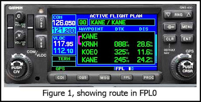
I went on a short training flight today with an instrument student in his C182, equipped with both a Garmin 430 and an MX20. My plan was to do a short flight to two nearby airports, New Richmond (KRNH) and Osceola (KOEO) and then return to Anoka (KANE), doing an approach at each airport. So he created a flight plan for our route. Entered into FPL0, it showed New Richmond as our active waypoint, which was precisely what we wanted.


When he selected PROC to load the GPS approach into KRNH however, it did not display the approaches for New Richmond, in spite of New Richmond being the active waypoint. The approaches for Anoka (KANE) were displayed, and this was not what was wanted.


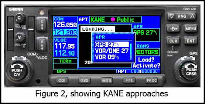
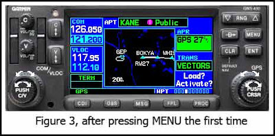
So how to do you get the approaches for New Richmond, which is where we’re headed? As you might suspect, there is a trick to doing it. While in the PROC page shown in Figure 2 and with the cursor activated, press MENU, and then press MENU a second time. The first time you press MENU, the named approaches box will disappear and you will be left with the box showing the highlighted approach in green, as shown in Figure 3.


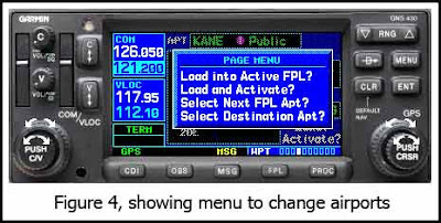
When you press MENU a second time, it will bring up a dialog box that allows you to change which airport you want, as shown below.


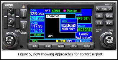
When you turn on the cursor and select “Select Next FPL Apt?”, magically the approaches for KRNH appear. Now you can select the approach you want at New Richmond, and life is good again.


Just make sure, however, that the approach you planned on doing is really available. More on that next time, subtitle “How Little Things Can Really Trip You Up.”